Land Survey Documents in Karnataka (ಸರ್ವೇ ದಾಖಲೆಗಳು)
Department of Survey Settlement and Land Records Documents
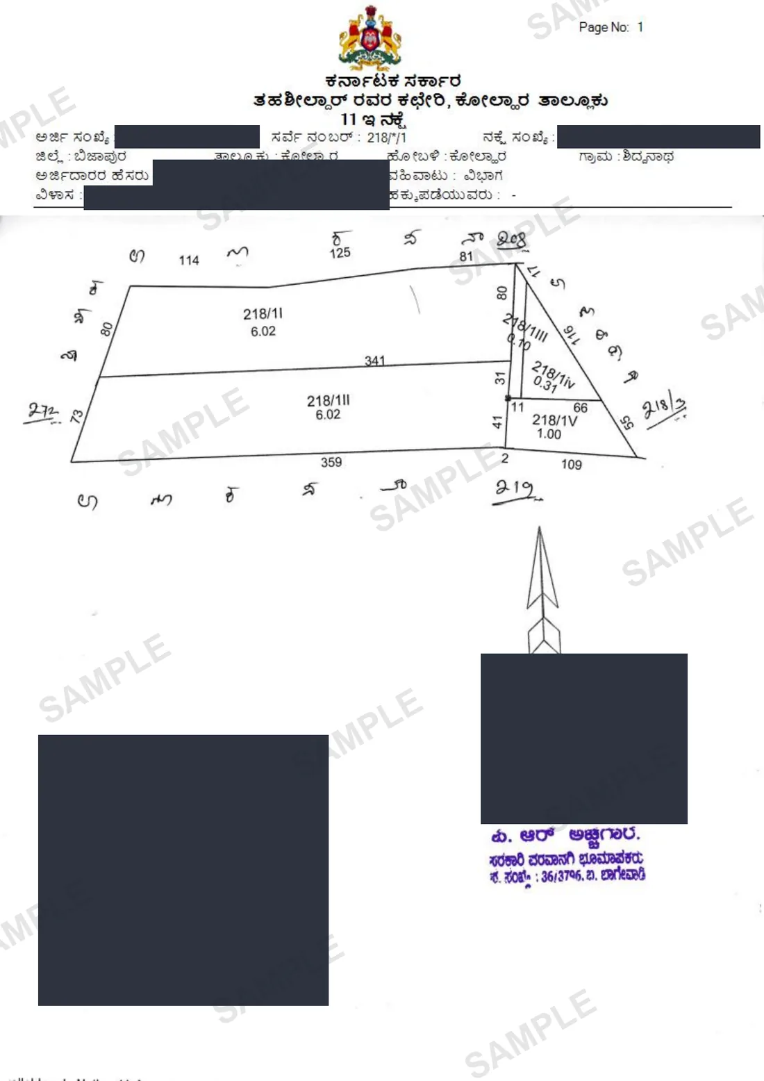
The essential suite of technical land survey records (Tippan, Akarband, 11E, etc.) defining the exact physical boundaries, measurements, and sub-divisions of a property.
Your Survey Docs, in about 12 seconds.
Median of 42 delivered orders, straight from SSLR / Bhoomi / Mojini.
In Kannada: ಸರ್ವೇ ದಾಖಲೆಗಳು·Also known as: Tippan · Atlas · Pakka book · Hissa sketch · 11E sketch · survey maps · SSLR survey records
How we know this: we retrieve the Survey Docs from SSLR / Bhoomi / Mojini for clients every working day, so the steps, failure modes and workarounds below are what the portal actually does — not a summary of its documentation.
Shubham Tiwadi is a partner at Anashwar Property Solutions in Vijayapura. His team operates the retrieval systems that pull Karnataka land records directly from the Bhoomi, Kaveri Online and e-Aasthi portals, and handles title verification for buyers across Vijayapura district.
What is the Survey Docs?
Survey Documents (ಸರ್ವೇ ದಾಖಲೆಗಳು) refer to a comprehensive bundle of technical mapping and measurement records maintained by the Department of Survey Settlement and Land Records (SSLR) in Karnataka. These documents are distinct from title deeds; while a sale deed proves *who* owns the land, survey documents prove *where* the land is physically located, its exact shape, and its precise measurements. The bundle typically includes the 'Tippan' (the original rough sketch and field measurements made during the first survey), the 'Akarband' (the register establishing the total area, classification, and land revenue assessment of a survey number), the 'Atlas' or 'Pakka Book' (the finalized, fair-copied map of the survey number), the 'Hissa Sketch' (a map showing how a main survey number was sub-divided into multiple smaller 'hissas' or sub-numbers among family members), and the '11E Sketch' (a mandatory pre-registration sketch required when selling a portion of an agricultural survey number). These documents are digitized and managed through integrated portals like Bhoomi and Mojini, providing the spatial truth that backs up the textual data found in an RTC (Pahani).
Why you need this
Relying solely on a sale deed or an RTC without verifying the underlying Survey Documents is a massive risk, particularly when purchasing agricultural land, rural parcels, or newly converted layouts. Boundary disputes are the most common cause of property litigation in India. Survey documents provide the indisputable government-sanctioned measurements needed to physically identify the property on the ground and resolve encroachments. For instance, an RTC might state you own 2 acres in Survey No. 45, but only the Hissa Sketch can tell you exactly *which* 2 acres within that larger survey number belong to you (North, South, East, or West). Furthermore, under Karnataka law, if you are buying a portion of an agricultural land parcel, the Sub-Registrar will completely refuse to register the sale deed without an approved 11E Sketch from the Mojini system, which mathematically demarcates the exact portion being sold. If a developer is converting agricultural land to form a residential layout, verifying the original Akarband and Tippan is crucial to ensure they actually possess the total extent of land they are claiming to develop, preventing you from buying a plot that physically falls outside their legal boundaries.
What the Survey Docs contains
- Precise linear measurements and geometric shape of the survey number or sub-division
- Total geographical extent (area) classified into cultivable land, kharab (unassessed/unusable) land (A-Kharab and B-Kharab), and phot kharab
- Adjacent survey numbers forming the boundaries (North, South, East, West)
- Details of original land assessment and revenue rates (Akarband)
- Signatures of the licensed surveyor, Revenue Inspector, and Tahsildar
- Unique Mojini application numbers and barcodes for modern 11E and Phodi sketches
Step by step
How to get the Survey Docs online
- 1
Identify the exact District, Taluk, Hobli, Village, Survey Number, and Hissa (sub-number) of the property.
- 2
For basic viewing of digitized maps like the village map or basic survey sketches, visit the official SSLR (landrecords.karnataka.gov.in) or Bhoomi portal.
- 3
To obtain certified copies of historical survey documents (Tippan, Akarband, old Hissa sketches), you must visit the Survey Department office located at the Taluk Tahsildar office.
- 4
Submit a formal application providing the survey details and pay the requisite government fee.
- 5
For a new sub-division sketch (11E Sketch) required for registration, you must apply through a licensed surveyor via the Mojini software system at the Taluk office.
- 6
The licensed surveyor will physically visit the site, measure the boundaries, upload the coordinates to Mojini, and the Tahsildar will approve and issue the digitally signed 11E sketch.
- 7
Ensure the downloaded or issued survey document has the official seal or digital barcode for legal validity.
The official portal is Bhoomojini (Mojini v3) bhoomojini.karnataka.gov.in (Survey Settlement and Land Records (SSLR)) · SSLR Revenue Maps landrecords.karnataka.gov.in/service3 (Survey Settlement and Land Records (SSLR)) · Bhoomi landrecords.karnataka.gov.in (Revenue Department, Government of Karnataka). We fetch from it on your behalf — you never need to register there.
Anashwar Docs runs this sequence for you against the government portal and returns the PDF in 12 seconds. Fill the form above to get it now.
What goes wrong
Common Survey Docs mistakes
Ignoring the 'Kharab' land details in the Akarband. B-Kharab land belongs to the government (e.g., a pathway or stream) and cannot be sold or converted. If a seller includes B-Kharab in the sale area, the transaction is invalid.
Proceeding with a partial land purchase without an approved 11E sketch. Sub-Registrars strictly enforce this rule; without the Mojini-approved sketch, your registration will be halted on the day of the appointment.
Assuming physical fences match the official Tippan. Fences shift over decades. Always hire a private licensed surveyor to measure the physical land against the official government Tippan before purchasing large parcels.
Overlooking discrepancies between the RTC and the Akarband. The total area mentioned in the RTC must exactly match the area established in the Akarband. Any mismatch indicates a revenue record error that must be fixed via mutation.
Buying sub-divided land (Hissa) where the formal 'Phodi' (division of survey numbers) has not been officially completed and mapped by the survey department, leading to overlapping claims with neighbors.
Fix errors fast
Survey Docs troubleshooting guide
| Symptom on SSLR / Bhoomi / Mojini | How to fix it |
|---|---|
| RTC shows 2 acres, but Akarband shows 1.5 acres | The Akarband is the foundational measurement document. The RTC is likely incorrect. You must apply for a record correction at the Tahsildar office before proceeding with any transaction. |
| Cannot find the survey number on the Bhoomi portal | The land might be unsurveyed, or it might be an inam/granted land that hasn't been fully integrated into the digitized records. Consult the Taluk survey office manually. |
| Sub-Registrar rejects the 11E sketch during registration | The sketch might have expired (they are typically valid for a specific period) or the details on the sketch do not perfectly match the schedule in the draft sale deed. Both must be identical. |
| Neighbor disputes the boundary during physical measurement | You must apply for an official 'Tatkal Phodi' or boundary fixation through the Tahsildar. The government surveyor will measure based on the original Tippan and establish the legal boundary. |
| Mojini application for 11E is stuck pending approval | Delays in Mojini often require physical follow-up at the Taluk office. The delay could be due to a pending objection from a neighboring landowner or a backlog at the surveyor's desk. |
Frequently asked questions
What are Survey Documents in Karnataka?
Survey Documents are technical mapping records maintained by the Department of Survey Settlement and Land Records. They include documents like the Tippan, Akarband, and Hissa sketch, which officially define a property's exact geographical location, boundaries, and measurements.
What is an 11E Sketch and when is it required?
An 11E Sketch is a mandatory, digitally approved survey map generated through the Mojini system. It is strictly required by the Sub-Registrar when you are buying or selling only a portion of a larger agricultural survey number, ensuring the exact sub-divided parcel is mapped.
What is the difference between an RTC and an Akarband?
The RTC (Pahani) is a register of rights showing current ownership and crop details. The Akarband is the foundational survey register that establishes the total area of the land, classifies it (e.g., cultivable vs. Kharab), and sets the land revenue assessment. The RTC is based on the Akarband.
What is 'Kharab' land mentioned in survey documents?
Kharab refers to uncultivable or unusable land within a survey number. 'A-Kharab' is unfit for farming (like a rocky patch) but belongs to the owner. 'B-Kharab' is reserved for public use (like a footpath, stream, or burial ground) and absolutely cannot be sold or converted by a private owner.
How can I resolve a boundary dispute with my neighbor?
You must apply to the Taluk Tahsildar for an official boundary survey. A government-licensed surveyor will use the original Tippan and survey documents to measure the land and officially mark the legal boundaries, which supersedes any physical fences.
40+ Survey Docs delivered across Karnataka
What customers say
"Super 👌"
— Shivappa
Related
Documents you may also need
PT Sheet / Survey Map
Official survey map (PT = Plane Table sheet) showing exact boundaries, dimensions, and neighbours of the land parcel.
ReadAkarband
The foundational survey settlement register detailing the total extent, kharab (uncultivable) land, and revenue assessment for a survey number.
ReadVillage Map
The macro-level SSLR survey map showing the layout of all survey numbers, roads, and water bodies within a revenue village. A crucial PDF download for spatial due diligence.
ReadE-Swathu Form 9
The primary property ownership record for non-agricultural land within Gram Panchayat limits, establishing legal title and assessment details.
ReadGuides
How to read and use Survey Docs
Mutation in Karnataka: How to Apply, Track the Status and Get the MR Extract in 2026
A registered deed does not change the RTC. Mutation is the Revenue Department's process that does — here is how to start it, why it stalls at the Village Accountant, and how to pull the MR extract once it is through.
How to Use BhoomiMaps: The Parcel Viewer Guide in Karnataka
A comprehensive guide to navigating BhoomiMaps, understanding digital parcel boundaries, and comparing its features against the Dishaank app and Mojini.
Anashwar Docs
Get your Survey Docs now.
Enter the details below. We fetch it from SSLR / Bhoomi / Mojini and return the official PDF in 12 seconds.