PT Sheet & Survey Map in Karnataka (ಸರ್ವೇ ನಕ್ಷೆ / ಟಿಪ್ಪಣಿ)
Land Parcel Map & Field Sketch
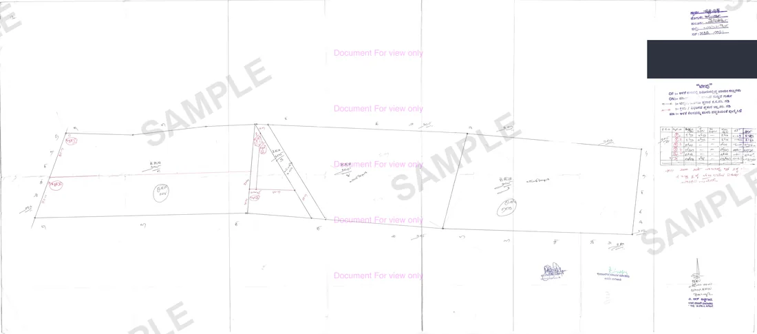
Official survey map (PT = Plane Table sheet) showing exact boundaries, dimensions, and neighbours of the land parcel.
Your PT Sheet, in about 16 seconds.
Median of 35 delivered orders, straight from BhoomiMaps / Mojini.
In Kannada: ಸರ್ವೇ ನಕ್ಷೆ / ಟಿಪ್ಪಣಿ·Also known as: survey sketch · Tippan · FMB sketch · Mojini sketch · plane table sheet
How we know this: we retrieve the PT Sheet from BhoomiMaps / Mojini for clients every working day, so the steps, failure modes and workarounds below are what the portal actually does — not a summary of its documentation.
Shubham Tiwadi is a partner at Anashwar Property Solutions in Vijayapura. His team operates the retrieval systems that pull Karnataka land records directly from the Bhoomi, Kaveri Online and e-Aasthi portals, and handles title verification for buyers across Vijayapura district.
What is the PT Sheet?
PT stands for Plane Table — the survey method used to draw it. The PT Sheet is the official parcel map produced by the Survey Settlement and Land Records Department, showing exact boundaries and dimensions of a survey number or city-survey property.
Why you need this
Boundary disputes are the most common property litigation. If physical boundaries don't match the PT Sheet, you may be purchasing the wrong parcel. The PT Sheet is the definitive legal reference.
What the PT Sheet contains
- Scaled sketch of the land parcel boundaries
- Survey number and area in official units (acres / guntas)
- Neighbouring survey numbers and their owners
- Roads, water bodies, or government land adjoining the parcel
- North direction indicator and scale
Step by step
How to get the PT Sheet online
- 1
Note the district, taluk, hobli, village and survey number from the RTC.
- 2
Open the survey records service — BhoomiMaps for rural parcels, Mojini for survey sketches and measurement requests.
- 3
Select the location cascade and enter the survey number to retrieve the sheet.
- 4
Download the sketch and compare its dimensions against the extent stated on the RTC.
- 5
Walk the site with the sheet. Physical boundaries that do not match the sketch are the single loudest warning sign in a land purchase.
The official portal is Bhoomojini (Mojini v3) bhoomojini.karnataka.gov.in (Survey Settlement and Land Records (SSLR)) · Bhoomi landrecords.karnataka.gov.in (Revenue Department, Government of Karnataka). We fetch from it on your behalf — you never need to register there.
Anashwar Docs runs this sequence for you against the government portal and returns the PDF in 16 seconds. Fill the form above to get it now.
What goes wrong
Common PT Sheet mistakes
The sheet shows the surveyed boundary, not the fenced boundary. Encroachment only shows up when you overlay the two.
Extent on the sketch and extent on the RTC frequently disagree by a few guntas. The sketch governs the shape; the RTC governs the revenue extent. Reconcile both before paying.
Adjoining government land, tank bund, or road widening reservations appear on the sheet and nowhere else.
Older sheets pre-date re-survey. If the village has been re-surveyed, the current sheet may carry a different survey number for the same land.
A sketch is not a measurement. For a disputed boundary you need a surveyor-attested measurement, not a downloaded sheet.
Fix errors fast
PT Sheet troubleshooting guide
| Symptom on BhoomiMaps / Mojini | How to fix it |
|---|---|
| Sketch extent differs from RTC extent | A few guntas is normal transcription rounding. Several guntas needs the Mutation Register and the sub-division record. |
| Sketch does not match the physical boundary | Possible encroachment in one direction or the other. Commission a licensed measurement before paying. |
| Record not digitised | Older Tippans for some villages exist only on paper at the taluk survey office and need a physical application. |
| Measurement request sits unassigned | Licensed surveyor capacity per hobli is finite and queues before harvest and registration season. Apply early. |
| Sketch shows a road or drain crossing the parcel | A public right of way or government land inside the boundary. Treat as a material defect and get it read by an advocate. |
| Buying part of a survey number | You will generally need an 11E sketch for the Sub-Registrar to register the sub-divided portion. |
Frequently asked questions
What is the full form of PT Sheet?
PT stands for Plane Table. A PT Sheet is the plane-table survey sheet — the scaled parcel map drawn by the Survey Settlement and Land Records Department during a survey. It is often assumed to mean "property tax", which is wrong; the sheet records boundaries and extent, not tax.
What is a PT Sheet in land records?
A PT Sheet is the official survey map for a land parcel. It shows the scaled boundary of the parcel, its dimensions, adjoining survey numbers, and any roads or government land touching it. The RTC says who owns the land; the PT Sheet says where it is and how big it is on the ground.
What if the survey sketch does not match the physical boundary?
That is an encroachment or a mis-described parcel, and it is the most common cause of property litigation in Karnataka. Do not proceed on the seller's assurance — commission a surveyor measurement before paying.
Is a PT Sheet the same as an FMB or Tippan?
They are closely related survey records. Tippan and FMB are field measurement sketches; the PT Sheet is the parcel map derived from them. For due diligence, obtain whichever the department holds for your survey number.
How do I get a PT Sheet online in Karnataka?
For rural survey numbers, open BhoomiMaps or the Mojini survey service, select district, taluk, hobli and village, enter the survey number and download the sketch. For city-survey properties the PT Sheet is held by the City Survey office under the Survey Settlement and Land Records Department and is applied for there. Anashwar Docs retrieves either version for you from the correct source.
30+ PT Sheet delivered across Karnataka
What customers say
"Excellent service. Found a plot on Solapur Road within a week. The consultant was very knowledgeable about the local market and helped negotiate a fair price. Highly recommend."
— Praveen Kulkarni
"Listed my house through Anashwar and got serious buyers within days. My contact number was never shared publicly — exactly what I wanted. Professional and trustworthy team."
— Shreya Patil
"Very transparent process. The consultant showed us properties matching our exact budget and requirements. No time-wasting. We bought a flat on Bangalore Road — very happy."
— Rajesh Desai
"I was nervous about listing my agricultural land but the team made it simple. Only 2% commission on sale, complete privacy, and sold within 3 weeks. Cannot ask for more."
— Anita Hiremath
Related
Documents you may also need
Bhoomi RTC — Pahani / Utara
Primary land ownership record from the Bhoomi portal — confirms who owns the land, land type, area, and tenancy.
ReadNA Order
Confirms agricultural land has been legally converted for residential or commercial use — and how to check the status of a pending conversion.
ReadMutation Register (MR)
Traces every ownership change — sale, inheritance, partition, court order — from earliest records to today.
ReadGuides
How to read and use PT Sheet
PT Sheet vs Tippan vs Akarband vs 11E Sketch: Which Survey Record to Use in 2026
A comprehensive guide to understanding Karnataka's four primary survey records—PT Sheet, Tippan, Akarband, and 11E Sketch—and knowing exactly which document is needed for your specific property transaction.
Who can buy agricultural land in Karnataka, and what still restricts it
Karnataka opened agricultural land to non-farmers in 2020. Sellers now describe it as unrestricted. Four separate restrictions still apply and any one of them can void your purchase.
Bhoomi RTC shows "No Record Found" — 9 causes and how to fix each
The Bhoomi portal says your survey number does not exist. It almost always does. Here are the nine reasons the lookup fails and what to do about each one.
Dishaank: finding a Karnataka survey number from the map, not the paperwork
Every other land record starts with a survey number. Dishaank is the one that starts with a location — which makes it the tool you need when the number is exactly what you have lost.
Gunta, acre and square feet: reading Karnataka land measurements
An RTC that reads "2-15" means two acres fifteen guntas, not two point one five. Getting that wrong changes the extent by a third and it happens constantly.
Land records in Vijayapura district: taluks, SROs and the Bijapur name problem
Vijayapura throws two problems no state-level guide covers: a taluk reorganisation the portals lag behind, and a city that answers to two names across forty years of documents.
Mojini, Tippan and Akarband: how to get a Karnataka survey sketch
Boundary disputes are the most common property litigation in Karnataka. The survey sketch is the document that settles them — and almost nobody explains which of the four records to ask for.
NA conversion in Karnataka: what the DC order does and does not permit
A conversion order is granted for a specific extent and a specific purpose. Buyers routinely assume it covers the whole survey number and any use. It usually does neither.
Anashwar Docs
Get your PT Sheet now.
Enter the details below. We fetch it from BhoomiMaps / Mojini and return the official PDF in 16 seconds.